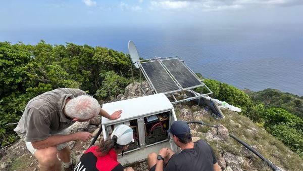
Last week, a team from the Royal Netherlands Meteorological Institute (KNMI) was here on Saba to maintain the modern seismic and volcano monitoring network, under the leadership of volcanologist Elske de Zeeuw van Dalfsen. The team, including seismologist Reinoud Sleeman, geodesist Andreas Krietemeyer, and technician Thomas Ritsma, operates with the primary objective of ensuring the island’s safety and preparedness for seismic and volcanic events.
The network’s purpose is to continuously monitor Mt. Scenery and the seismic activity, enabling early warnings for volcanic unrest and potential tsunamis, as well as contributing data to the Pacific Tsunami Warning Center. Such monitoring is essential for the community’s safety and for the timely dissemination of information in case of natural events. Elske de Zeeuw van Dalfsen comments that “With this monitoring network, early warnings can be given in case of volcanic unrest or tsunamis caused by earthquakes. In case of a felt earthquake, we are able to give information on the location, magnitude and depth of the earthquake”.

The routine maintenance involves regular system checks, vegetation clearance, software updates, data retrieval, and repair of any damaged equipment. For instance, recent maintenance included the replacement of the VSAT dish arms at Grey Hill and the installation of an additional solar panel to ensure uninterrupted operation. Other technological advancements have also been incorporated into the network’s operations. In 2022, four experimental GNSS units were installed to detect surface deformations, potentially enhancing monitoring capabilities not just on Saba, but also in other regions.
Furthermore, the equipment is managed remotely, with alerts set up for operational failures. Local assistance is sometimes sought for minor issues, while the team does visit the island approximately twice a year for more complex maintenance requirements. The team stays in regular contact with the Public Entity to report on the network’s status and the objectives during their visits.
“The local government has always been very supportive. Helping with permission for the building of a monitoring site, requesting help from the military to carry equipment and building materials to Grey hill, and explaining the importance of our work to the residents. Without this support it would be impossible to do our job” states Elske de Zeeuw van Dalfsen.
The data collected from Saba’s monitoring equipment is publicly available under the Creative Commons license, allowing for broader research utilization across the Caribbean and beyond. You can find live information at https://www.knmidc.org/seismology/
The KNMI team urges Saba’s residents to recognize the monitoring network’s importance, particularly its role in providing warnings during potential crises. The team expresses appreciation for the local support and understanding of their work and encourages open communication with the community through their “Volcano Monitoring” Facebook page at https://www.facebook.com/groups/191096753226885
GIS.

 Saba News News and Information from Saba Island, Dutch Caribbean
