
A new initiative on Saba is inviting residents and visitors to participate in monitoring the island’s natural environment by simply taking a photograph.
The Sea & Learn Foundation, in partnership with the Saba Conservation Foundation, has launched “Hope Spot Stops,” a citizen science project designed to track environmental changes across key sites on the island. The initiative supports Saba’s designation as a Mission Blue Hope Spot, which recognizes areas of critical importance to ocean health.
How It Works
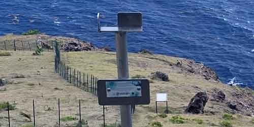
Each Hope Spot Stop features a specially designed photo station based on the global CoastSnap concept, which encourages people to take repeat photographs of the same landscape over time. When uploaded, these photos create time-lapse sequences that help scientists monitor environmental changes, including coastal erosion, vegetation growth, and the impacts of climate change.
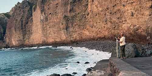
Six stations are currently operational at Well’s Bay, Dancing Place, Thais Hill, Saba Botanical Garden, Spring Bay, and Sulphur Mine. Additional Hope Spot Stops will be installed in the coming months on Mt. Scenery and at two underwater sites to monitor coral restoration, grazer impacts, and coral relocation efforts. These locations were selected for both their scenic value and the ecological data they can provide.
Scientific Methodology
Photos taken from each station are aligned at consistent angles and heights using a specially designed tray system.
Once submitted, they undergo processing through photogrammetry, a technique that converts images into usable data. This allows researchers to observe landscape changes over time and better understand long-term environmental trends.
Community Engagement Focus
Beyond its scientific objectives, the project aims to increase public engagement with Saba’s natural environment. “It’s about getting people outside, taking a moment to observe their surroundings, and realizing they can contribute meaningfully to conservation,” says Emily Malsack, Operational Director at Sea & Learn Foundation.
The initiative extends beyond tourism. Once the final terrestrial station is installed, the Sea & Learn Foundation will collaborate with local youth groups to promote participation, transforming the Hope Spot Stops into valuable educational tools. Organizers hope the project will inspire interest in science and conservation among younger generations.
Local Collaboration
The stations represent a true community effort, with several local organizations and individuals contributing to their success. The Saba Conservation Foundation assists with site suitability assessment and ecological focus determination. Triton Saba, NV handles fabrication of the custom stands, while Frank Granger, Sevlon Glasgow, and Dwayne Johnson manage installation, ensuring each post is properly reinforced and weather-resistant.
Future Development
A mobile application is currently under development to streamline photo uploads and provide users with information about each site’s ecological significance and broader conservation efforts across the island.
The Hope Spot Stops initiative receives partial funding from NEPP (Nature and Environmental Policy Plan), which supports conservation projects throughout the Caribbean Netherlands.
How to Participate
Participation is straightforward: visit any installed station, place your phone in the designated tray, take a photo, and email it to seaandlearnsaba@gmail.com. Each contribution becomes part of a growing database documenting Saba’s evolving landscapes, helping researchers, policymakers, and the community make informed decisions to protect the island’s future.
The project represents an innovative approach to environmental monitoring that combines rigorous scientific methodology with accessible public participation, creating a model for community-based conservation that other islands might well consider adopting.
Citizen science stations blend conservation with community engagement
